
|
EDTECH 541Becky Leavitt: MET Student
|
Internet Enriched Lesson
Unit Overview
As part of the 4th grade social studies curriculum, students conduct a study of maps. The activities in this unit were designed to address the curriculum elements related to the study of maps as listed below. For this unit, the learning activities were divided into two separate 4th grade Social Studies topics. Activity #1 is a follow-up to a previously completed lesson and therefore has separate objectives and learning outcomes.
Activity #2 is the new focus for this week and has new learning objectives and standards.
Activity #1
Overview
This lesson will be used as a follow up to the Oregon Trail lesson completed previously. In this activity, students will animate their travels on the Oregon Trail using a website called “Animaps.”
Objective
Students will apply their knowledge about the Westward Movement to convert their writing into a visual representation of their travels.
Lesson Description
As I was studying and exploring tools this week, I came across a tool called “Animaps” and I couldn’t resist! This is really just an extension to last week’s Oregon Trail lesson where students created journal entries describing their travels across the Oregon Trail in a wagon train. Using the details from the journal entries from that assignment, students will create a trip in Animaps that outlines their travels on the Oregon Trail.
Extension Activity
Tutorial
Activity #2
Overview
During this unit of study, 4th grade students will focus on maps. Specifically, students will learn the names of major geographic features in Idaho and will be able to identify them on a map. They will also learn the bordering states and country and where they are in relation to Idaho.
Objectives
Instructional Objective: Identify the geographic features of Idaho.
Performance Objective:
Instructional Objective: Use geographic skills to collect, analyze, interpret, and communicate data.
Performance Objective:
Lesson Idea
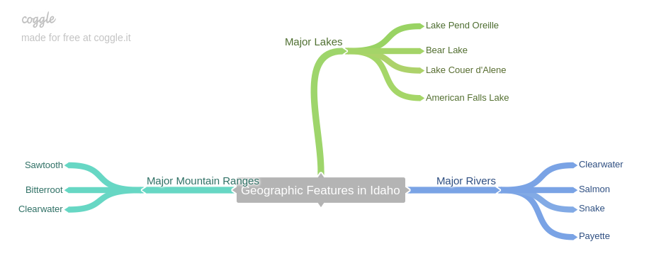
Students will conduct an Internet search to discover the major geographic features of Idaho. They will create a coggle to organize their research. Then, they will learn the specific locations of these features as they label a map of Idaho with major rivers, lakes and mountain ranges. They will save the completed map as an image and submit to Google Classroom.
Outlining key geographic features in Scribble Maps:
Suggested Geographic Features
Major Lakes
Pend Oreille Lake, Bear Lake, American Falls Reservoir, Lake Coeur d'Alene
Major Rivers
Snake River, Salmon River, Clearwater River
Major Mt. Ranges
Sawtooth, Clearwater, Bitterroot
Other
Mt. Borah (highest peak in Idaho)
Enrichment
Add an image of a compass rose to your map
How many states are located to the North of Idaho? to the South? West? East?
As part of the 4th grade social studies curriculum, students conduct a study of maps. The activities in this unit were designed to address the curriculum elements related to the study of maps as listed below. For this unit, the learning activities were divided into two separate 4th grade Social Studies topics. Activity #1 is a follow-up to a previously completed lesson and therefore has separate objectives and learning outcomes.
Activity #2 is the new focus for this week and has new learning objectives and standards.
Activity #1
Overview
This lesson will be used as a follow up to the Oregon Trail lesson completed previously. In this activity, students will animate their travels on the Oregon Trail using a website called “Animaps.”
Objective
Students will apply their knowledge about the Westward Movement to convert their writing into a visual representation of their travels.
Lesson Description
As I was studying and exploring tools this week, I came across a tool called “Animaps” and I couldn’t resist! This is really just an extension to last week’s Oregon Trail lesson where students created journal entries describing their travels across the Oregon Trail in a wagon train. Using the details from the journal entries from that assignment, students will create a trip in Animaps that outlines their travels on the Oregon Trail.
Extension Activity
Tutorial
- Go to Animaps and under the section titled, “How Does it Work?” click “Basics Tutorial”
- Watch the tutorial. Click “OK” when done
- Click the “Get Started” button
- In the upper right hand corner, click “Register”
- Use your school Gmail address and choose a password
- Record your password on your username tracking spreadsheet
- Refer to your notes from the “Oregon Trail” lesson for this part of the activity. Navigate to your starting point on the map. Use the record features to record a visual representation on the map of your travels during those three fictional days on the Oregon Trail. Include details such as where you stopped, how long you stayed, and landmarks encountered.
- Use the “quick image” feature in Animaps to insert images of landmarks and have them appear at specified times. You can enter a url or upload a photo from your PC.
- Use “Advanced Mode” to determine where you image will appear on the map.
- Use the “text” feature to add details of important events or locations as you pass them on the map
- Once your trip is complete, use the “link” “embed” feature to share this map with Miss Leavitt.
Activity #2
Overview
During this unit of study, 4th grade students will focus on maps. Specifically, students will learn the names of major geographic features in Idaho and will be able to identify them on a map. They will also learn the bordering states and country and where they are in relation to Idaho.
Objectives
Instructional Objective: Identify the geographic features of Idaho.
Performance Objective:
- Label a map of Idaho with rivers, lakes, mountain ranges, and other geographic features.
Instructional Objective: Use geographic skills to collect, analyze, interpret, and communicate data.
Performance Objective:
- Create and share a state map which includes compass rose, scale, boundary lines, bordering states and country, symbols, geographic features, latitude and longitude.
Lesson Idea
Students will conduct an Internet search to discover the major geographic features of Idaho. They will create a coggle to organize their research. Then, they will learn the specific locations of these features as they label a map of Idaho with major rivers, lakes and mountain ranges. They will save the completed map as an image and submit to Google Classroom.
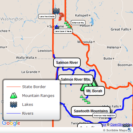
Outlining key geographic features in Scribble Maps:
- Go to scribblemaps.com
- Click “Create Your Map Now” to start a new map
- Make sure Google maps (the default) is selected.
- Click the road map (or toggle between maps to fit your needs)
- Using the drawing tool, draw the borders of Idaho and the major rivers and lakes (Snake River, Salmon River, Clearwater River, Pend Oreille Lake, Bear Lake, American Falls Reservoir, Lake Coeur d'Alene)
- Place a marker on Mt. Borah, and the major mountain ranges in Idaho (Sawtooth, Clearwater, Bitterroot)
- Use the search function of Scribble Maps to locate these features in Idaho or use the attached Reference Map of Idaho
- Add a label for the names of the six bordering states and the bordering country
- Edit the Map Legend by clicking on the pencil in the upper right hand corner
- Add: state border, rivers, lakes and mountain ranges to your legend
- Change the map view to “Terrain”
- Click “Menu,” “Save Image” to save an image of the map
- Submit it in Google Classroom
Suggested Geographic Features
Major Lakes
Pend Oreille Lake, Bear Lake, American Falls Reservoir, Lake Coeur d'Alene
Major Rivers
Snake River, Salmon River, Clearwater River
Major Mt. Ranges
Sawtooth, Clearwater, Bitterroot
Other
Mt. Borah (highest peak in Idaho)
Enrichment
Add an image of a compass rose to your map
How many states are located to the North of Idaho? to the South? West? East?
|
Example of a Coggle Mind Map
|
Example of Completed Map
Links and Resources
Animaps
Idaho Atlas: http://www.worldatlas.com/webimage/countrys/namerica/usstates/idland.htm
Idaho Geography Facts: http://www.netstate.com/states/geography/id_geography.htm
Scribble Maps: http://scribblemaps.com
Reference Map of Idaho: http://www.nationsonline.org/oneworld/map/USA/idaho_map.htm
Link to Map on Scribble: https://www.scribblemaps.com/create/#id=IdahoMap
Mind Mapping Website: https://coggle.it
